Home Existing Covered Bridges Bygone Covered Bridges Romantic Shelters About Covered Bridges Trusses News Links

North Branch Covered Bridge

COUNTY WORLD GUIDE # CROSSES TRUSS SPANS LENGTH BUILT GONE
Baltimore & Carroll MD-03-23x & MD-06-02x North Branch Patapsco River Unk Unk Unk 1854 1914
The North Branch Covered Bridge connected Baltimore County to Carroll County over the North Branch of the Patapsco River about 6 miles west of Randallstown. The bridge burned down on July 8, 1914. From an article in the Baltimore Sun, July 9, 1914:

North Branch Bridge Burned

Wooden Structure Over Patapsco River Was 60 Years Old

Fire destroyed the old wooden-covered bridge which spans the Patapsco River between Baltimore and Carroll counties, on the Liberty Road at North Branch, about 3 o'clock yesterday morning. The flames were discovered by Mildred Koiner, who gave the alarm. The Pikesville Volunteer Fire Department responded, but when the firemen arrived the bridge was doomed and they turned their efforts toward saving the North Branch Rolling Mills and the North Branch Hotel. In this they were successful.
The article dates the bridge back to 1854 although the first indication for building a bridge in this location is noticed on April 11, 1848 when the Baltimore Sun advertised the following to bridge builders:
NOTICE TO BRIDGE BUILDERS--OFFICER OF COMMISSIONERS OF TAX FOR BALTIMORE COUNTY, April 6, 1848.--Proposals will be received by the undersigned and by the Clerk to the Commissioners of Tax of Carroll County, in Westminster, up to the 2nd day of May, proximo, inclusive, for the building of a BRIDGE over the Patapsco Falls, at "Beem's Mill," upon the Liberty Road. Plans and specifications may be seen by application at this Office, or at the Office of the Commissioners of Tax for Carroll County. By order of the Commissioners of Baltimore County.--JNO. B. STANSBURY, Treasurer of B.C.
The destroyed covered bridge was replaced by a concrete bridge as reported in the Jeffersonian on October 10, 1914: "Work was in progress on a new concrete bridge near Harrisonville to replace the old wooden covered bridge burned last summer."
North Branch at Liberty Road in 1865
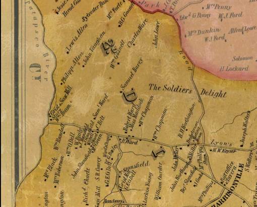
Simon J. Martenet Map of 1865 shows the location of the Wm Beam's Mill (also spelled Beem's), at Liberty Road, near the North Branch of Patapsco River crossing. (Center left of map). Lyon's Mill Rd and Liberty join at the fork just west of Harrisonville in Baltimore County.
In the 1800s and early 1900s the North Branch of the Patapsco River was narrow in the vicinity of the bridge. Baltimore County purchased land in this area in the 1930s and in 1942 Baltimore City announced that the area will become a reservoir for drinking water for the city residents. Work on the reservoir, known as Liberty Dam, started in 1947.

UPDATED: 04-21-2011 for newspaper article in 1914 about replacing covered bridge with concrete bridge.

Back to Bygone Covered Bridges

Maryland Covered Bridges
Email me: mdcoveredbridges@comcast.net