Home Existing Covered Bridges Bygone Covered Bridges Romantic Shelters About Covered Bridges Trusses News Links

Wetheredsville Covered Bridge

COUNTY WORLD GUIDE # CROSSES TRUSS SPANS LENGTH BUILT GONE
Baltimore MD-03-29 #1x Gwynns Falls Unk Unk 100' 1842-43 1868
Baltimore MD-03-29 #2x Gwynns Falls Unk Unk about 100' c1868 1910
A very historic area exists in the western section of Baltimore City, known as Dickeyville. Before it was Dickeyville, it was Wetheredsville, named after the three brothers who settled there in 1829, John, George and Charles Wethered. The Wethered Brothers converted the Franklin Paper Mill to a woolen mill, built another mill called Ashland and named the area of operation Wetheredsville. The mill was often referred to as Franklin Mills or Franklin Works, or Franklin Wollen Mills, and Franklin Wollen Factory. The Wethereds sold their property to William Dickey in 1871 and in 1896 the town was renamed Dickeyville. In the mid 1850s this area was a part of Baltimore County. The Baltimore City western limits were near where Frederick Road currently meets with West Pratt Street.
The Maryland Session Laws of 1840, Chapter 74, provided "an act empowering the Commissioners of Baltimore County to build a Bridge across Gwynn's Falls, at or near the Franklin Factory." The cost of the bridge was to not exceed $1,000. The act was passed on February 15, 1841.
An article appeared in the Baltimore Sun on October 12, 1842 to Bridge Builders about constructing the bridge at Franklin's Mill:
NOTICE TO BRIDGE BUILDERS--The undersigned, Commissioners for building a BRIDGE across Gwynn's Falls, at Wethered's, Franklin Factory, 5 miles from Baltimore, will receive sealed proposals for building said Bridge, until SATURDAY, 15th last. The abutments and wing walls to be made of Stone, the span to be made of the best quality Timber and to be roofed. Any further information will be given to those wishing to contract, by calling on either of the Commissioners. John Wethered, Franklin Factory, Paul Rust, Windsor Mill Road, Beale Randall, Liberty Road.
A report in the Baltimore Sun about the freshet of 1867 leads to confusion about whether or not the covered bridge at Wetheredsville was lost. The article stated, "it is learned that the bridge at Wetheredsville is also gone." The report did not specifically state that it was a covered bridge. There were many bridges in the general Wetheredsville, Franklintown, Winsor Mill and Liberty Road area.
However, another article in the Baltimore Sun about the freshet of July 1868, said the following:
GWYNN'S FALLS--On this stream, the abutment of the bridge on the Liberty Pike was carried away. The Powhatan Dam was much injured, about one half being destroyed. It was, however, only a temporary dam. Mr. Slowshower's bridge was carried away; also the county covered bridge at Wetheredsville. The abutments of the latter were undermined, and the whole mass fell over in a body--it had a span of 100 feet.
A book by John Dorsey and James D. Dilts titled A Guide to Baltimore Architecture includes a passage about the loss of Wetheredsville Bridge: "Another great freshet in 1868 demolished a covered bridge at Wetheredsville and carried away part of the old schoolhouse."¹
Although unable to find information about the rebuilding of the Wetheredsville Bridge, a report in the Baltimore Sun on March 29, 1908 refers to the covered bridge while taking readers on a driving tour of the area:
MOTORING ON THE BOULEVARD-TO-BE--The run can be concluded by continuing upstream and passing through Dickeyville to the road to the right at the end of the village. Regain the east side of the falls here by the old-time covered bridge, and go uphill and on to Forest Park.
A previous article in the Baltimore Sun on September 29, 1907, also a driving tour, included a map and more specific driving directions:
DICKEYVILLE BY MOTOR: A GUIDE FOR AUTOISTS--The next road you come to, half a mile from the cemetery, is Gwynn Oak Avenue. Take this to the right until you come to Windsor Mill road again, about half a mile or so from the Franklin road. Take this to the right and up a long hill till you come to the Forest road again. Turn down this to the left to Dickeyville, and when there turn along its one street until beyond the hill. Here, turn right, go down the hill and through the covered bridge, and then up the hill, which is still the Forest road. This will bring you to Forest Park.
Wetheredsville in 1865 Wetheredsville Driving Tour
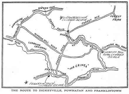
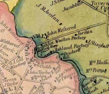
Simon J. Martenet Map of 1865 shows the location of the Franklin Woolen Factory in Wetheredsville. Driving Tour map of the Wetheredsville/Dickeyville area from the Baltimore Sun article on September 29, 1907. (Added to map are three marks where covered bridges were known to exist.)
We have no information as to when the second bridge was built, but suspect it was shortly after the freshet of 1868. However, we have confirmation about when the old covered bridge was replaced. The Baltimore Sun carried an article in its January 24, 1910 paper stating: "The Dickeyville Bridge has just been completed, and is the largest bridge in the county. It has two 50-foot spans and is 120 feet over all. It is of reinforced concrete, and cost $7,530."

¹ John Dorsey, James D. Dilts, A Guide to Baltimore Architecture, Third Edition (Tidewater Publishers, Centerville, Maryland:1997), p. 301.

Updated 11/6/2013 for additional source verifying loss of the first Wetheredsville Bridge in 1868. Special thanks to fellow researcher Mary Ann Ricker for providing information about this source.

Back to Bygone Covered Bridges

Maryland Covered Bridges
Email me: mdcoveredbridges@comcast.net